|
|
|
| Walk in England | |
|
Front |
News |
Mountain cams |
Walks in England |
Walks in Scotland |
Walks in Wales |
Weather |
Links
|
|
|
Click on photo for map
|
|
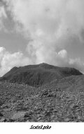 |
Great Langdale to Scafell. MAPS: OS OD6-English Lakes SW, L90-Penrith & Keswick,T3-Lake District.Start & Finish: Old Dungeon Ghyll Hotel (SD 285062).Length:12mls. Time: 8hrs apx. Descent & Ascent: 2600m 8500ft.Access : March to December Difficulty : Summer a long high mountain route no tec difficulty.Winter a serious expedition only for the experienced. The Route. From the car park to stool End Farm.Go straight up the ridge behind the farm(The Band) to the col between Bowfell & Crinkle Crags.Over the summit of Bowfelldescend to Esk Hause via Esk Pike. Turn off in a semi circular route over Broad crag to a dip before a steep ascent onto the summit of scafell pike.Go back the same way then go onto Great End to Esk Hause & descend via the old pony track all the way down to Rosset Gill.Back along the valley of Mickleden. -------------------------------------------------------------------------------- |
| Fairfield Horseshoe MAPS: OS OD7 OD5-The English Lakes (SE & NE Sheets)Start & Finish:Ambleside NY 375045 Length:12mls. Time 7hrs Apx. Descent & Ascent :1680m 5500ft.Access : April to October Difficulty :No tec difficultys but the going is sustained. The Route. Take the Kirkstone road out of Ambleside left at Nook Lane till you come to Nook end Farm over low Sweeded Bridge to gain the fell.Go up the trak to Scandale fell, the way is obvious, to Low Pike continue along the horseshoe rim to eventually gainthe top of Fairfield. From the summit you go back on your self a littel way to gain the descent ridge down to Greatrigg & the Rydal Fell. ------------------------------------------------------------------------ |
 |
|
|
|
|
|
|
|
|
|
|
|
|
|
|
|