|
|
|
| Walks in Scotland | |
|
Front |
News |
Mountain cams |
Walks in England |
Walks in Scotland |
Walks in Wales |
Weather |
Links
|
|
|
Click on photo for map |
|
|
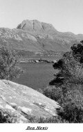
Ben Nevis MAPS: L41-Ben Nevis, T7 - Ben Nevis & Glencoe.Start & Finish:Glen Nevis YH (NN 128718) Length:9mls. Time:9hrs Apx. Descent & Ascent :2728m 8950ft.Access : June to September Difficulty :High mountain walk a bit easy scrambling only to be tackled in good conditions. The Route .Start at the Youth Hostel in Glen Nevis on the Mountain Track. The track continues to rise as it skirts the western side of Meall an t-Suidhe, zigzagging twice and crossing a couple of streams by means of a couple of small metal bridges. The track then starts to veer northwards, following the western bank of the Red Burn Gully. Another, larger zigzag takes you up to the saddle between Ben Nevis to the east and Meall ant-Suidhe to the west.The track passes to the east of Lochan Meall an t-Suidhe that lies in the saddle. It then turns to the right to start the ascent up the western side of Ben Nevis. At NN 1473 7186 the track crosses the Red Burn under a waterfall, and this marks the halfway point of the ascent.From the Red Burn the track continues up the northwestern shoulder of Ben Nevis in a series of four giant zigzags, and the gradient of the track starts to flatten out as it heads in a westwards direction. One last, but thankfully short, ascent of McLean's Steep leads to the summit plateau. Across here careful navigation is needed to reach the summit cair. The summit plateau is bounded on the northeastern side by some very steep drops, including Tower Gully and Gardyloo Gully, which the path runs adjacent to. Be careful to avoid these gullies,down on the same route that you came up. -------------------------------------------------------------------------------- |
 |
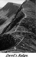
| The Mamores Traverse. MAPS: OS L41 - Ben Nevis & Glencoe - Ben Nevis T7.Start & Finish: Car park at the top of Glan Nevis ( NN 168692)Length: 9.5 miles. Time: 9 hrs apx.Descent & Ascent : 3283m (10770ft).Access : May to September. Difficulty : A sustained mountain walk with a bit of easy scrambling.Well defind paths going is good underfoot. The Route. From the car park go up the path into the upper Glen Nevis.Over the wire bridge past the Steall Falls to the Zig-Zag upto the shoulder of An Gearranach along the ridge scramble up come off on the second peak (An Garbhanach).Descent down to the hollow then steeply to the summit of Stob Coire a Chairn.Drop down its shoulder to the col under Am Bodach, then the big pull to the top(5hrs, 1034m, 3391ft). Down and along to Crast Sgor an Iubhair. Zig-Zag down to the start of the ridge along to top of Stob Coire a Mhail drop to the narrows of the Devils Ridge.(A pinnacle can be scrambled over).Up to the summit of Sgurr a Mhaim (6hrs 1098m 3601ft).Then a long fall down the shoulder to the road bridge at Polldubh.Up the road back to the car park--------------------------------------------------------------- |
 |
|
|
|
|
|
|
|
|
|
|
|
|
|
|
|