|
|
|
| Walks in Wales | |
|
Front |
News |
Mountain cams |
Walks in England |
Walks in Scotland |
Walks in Wales |
Weather |
Links
|
|
|
Click on photo for map |
|
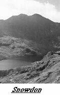 Snowdon Horseshoe. MAPS: OS OD17 Snowdonia National park, L115 Snowdon, T10 Snowdonia & Anglesey. Start & Finish: Pen y Pass (647557)Length: 7.5mls Time:6hrs apx. Descent & Ascent :1981m, 6500ft.Access : summer conditions only Difficulty :A long serious mountain walk small bit of scrambling a higgh degree of exposure. The Route. Start along the Pyg Track and follow it as far as Bwlch y Moch (Pass of Pigs). Turn off the Pyg Track, heading up the lower slopes of the ridge of Crib Goch. The ridge is tackled head-on to gain the Crib Goch proper. The route continues along the trickiest part of the ridge, a rocky tightrope with steep drops on either side. Care is needed here, especially at the pinnacles, as a fall could kill you. The ridge continues on along Crib y Ddysgl, leading to the summit of Garnedd Ugain. From there follow the path around to the left to join the Llanberis Path alongside the railway, following them to the summit. If by now the conditions are poor it would be best to descend via the well-known Pyg or Miners' Tracks. Otherwise, leave the summit to the following the Watkin Path down to the large cairn at Bwlch Ciliau (Pass of River Sources); the shaley path is treacherous in the wet and loose in the dry. Leave the Watkin path and follow the ridge over the peaks of Lliwedd before following the rocky descent (with a little scrambling) down the ridge to Llyn Llydaw. At the lake, the path joins the Miners' Track to return to Pen-y-Pas. ---------------------------------------------------------------- |
|
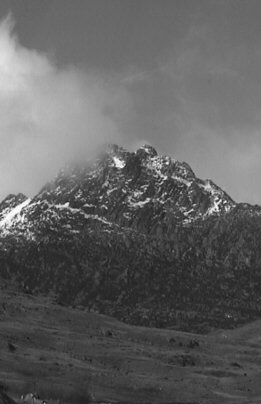 Tryfan's North Ridge & the Glyders MAPS: L115 Snowdon & Surrounding Area, T10 Snowdon & Anglesey.Start & Finish:Car park by Llyn Ogwen (SH 662603) Length:5mls Time:7hrs Apx. Descent & Ascent :1978m, 6490ftAccess :April to October Difficulty :Quite difficult scramble up the north face a bit easy climbing sections but a straightforward mountain walk. The Route. From the car park go throw a littel gate & travese up & left under the Milestone Buttress over the wall via the wooden stile.Continue up to the shoulder then go straigt up the middle of the ridge.there is a bit of scrambling befor the top of Tryfan (917m).From the summit drop to the gap separating it from the Glyders then over the wall on the left take the path on the left of the buttress above.Over the summit of Glyder Fach (994m) take the long easy ridge to the top knoll of Glyder Fawr(999m).Ok down the shoulder untill opposite Llyn y Cwn.Down the path on the right down through the Devils Kitchen into Cwm Idwal.Go past Cwm Idwal a steep descent leads to Ogwen Cottage.Then along the A5 to the finish. --------------------------------------------------------------------------------- |
|
|
|
|
|
|
|
|
|
|
|
|
|
|
|
|